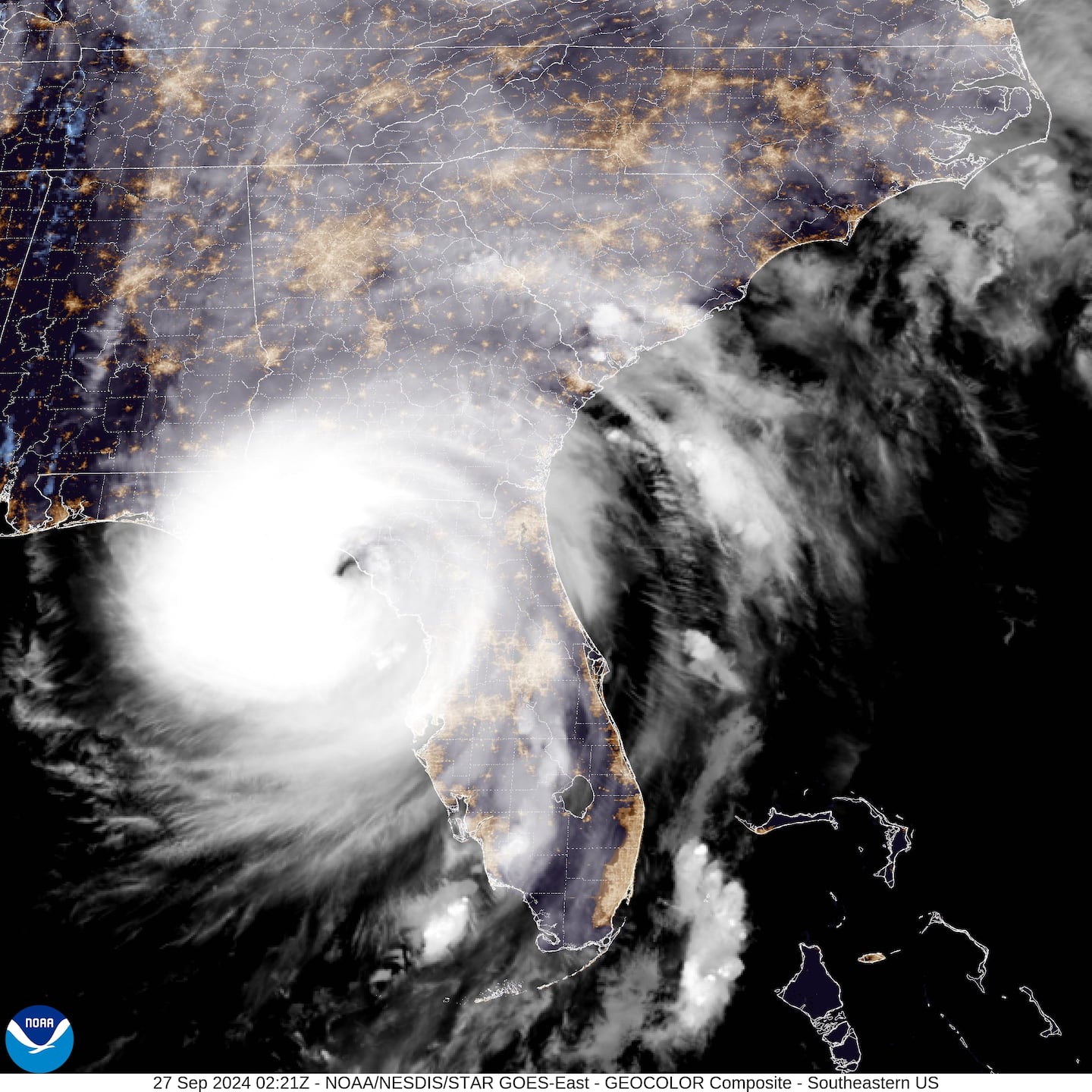
ORLANDO, Fla. — Channel 9 meteorologists are tracking Hurricane Helene as it made landfall near the Big Bend in Florida.
See our new live updates story for Friday, Sept. 27, by clicking here.
▶ WATCH CHANNEL 9 EYEWITNESS NEWS

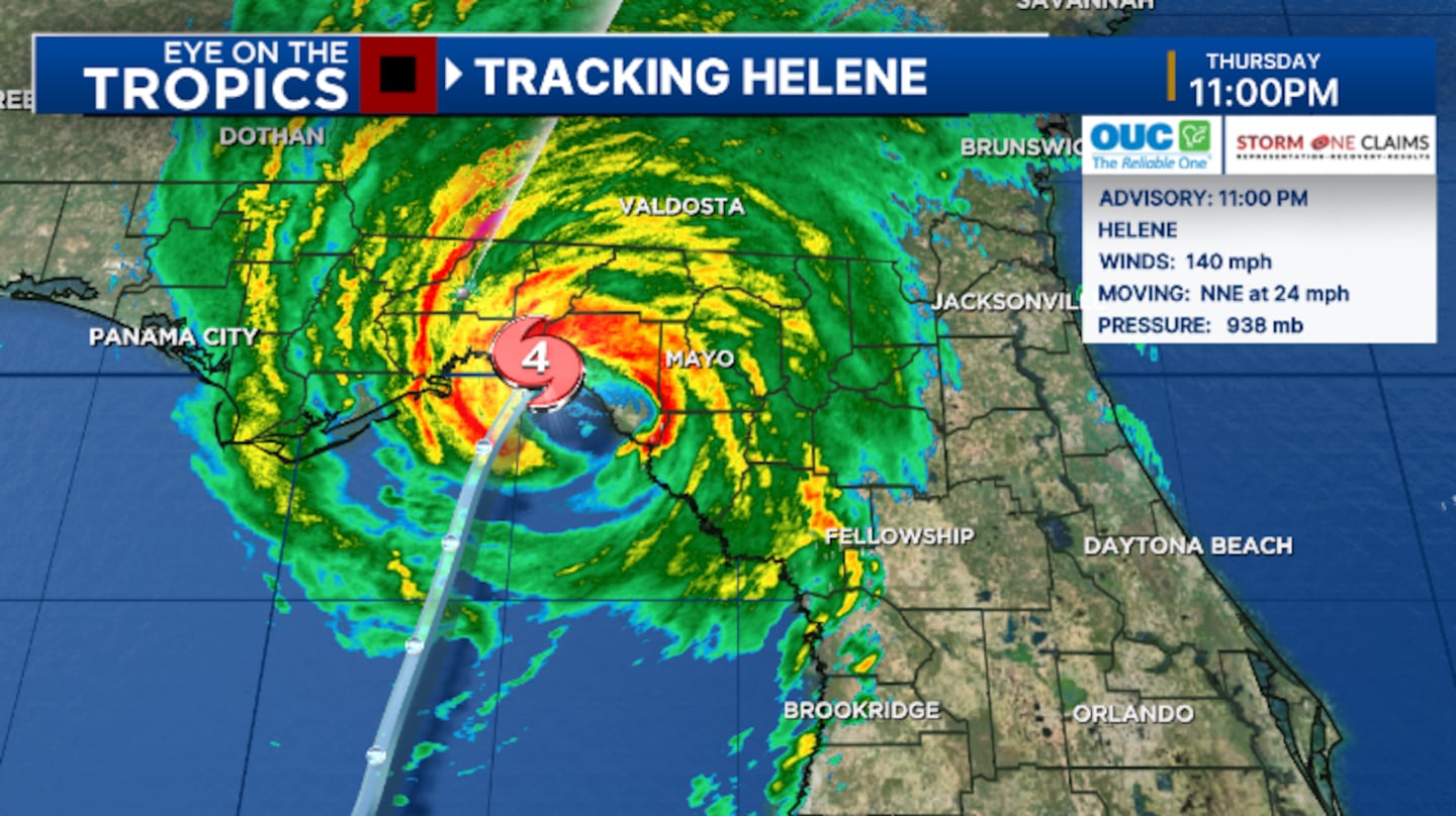
11:25 p.m. update:
Helene has made landfall in the Florida Big Bend as a Category 4 major hurricane.
The storm made landfall just east of the mouth of the Aucilla River. This is 10 miles west-southwest of Perry.
Winds are at 140 mph with a minimum pressure of 938 mb.
This is the strongest hurricane to hit the Big Bend area in recorded history.
11 p.m. update:
Helene is nearing landfall at 11 p.m.
Winds are at 140 mph as Helene remains a dangerous Category 4 major hurricane.
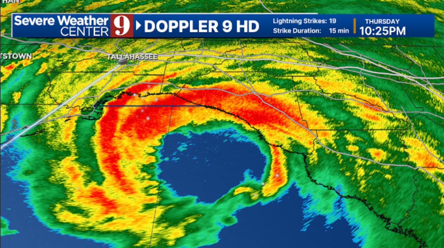
10:30 p.m. update:
Helene’s eyewall is now moving into Taylor County.
An Extreme Wind Warning remains in effect for parts of the Big Bend, where winds over 115 mph are possible.
Landfall is now imminent for Taylor County in the next hour, with catastrophic storm surge and intense hurricane-force winds.
9:23 p.m. update:
An extreme wind warning has been issued for a large portion of the Big Bend until midnight.
This includes eastern portions of metro Tallahassee.
The eyewall of Hurricane Helene will begin to move onshore over the next hour.
Extreme wind warnings are issued only when winds are expected to be 115 mph or greater.
The National Weather Service requests residents to shelter-in-place as the eyewall moves through.
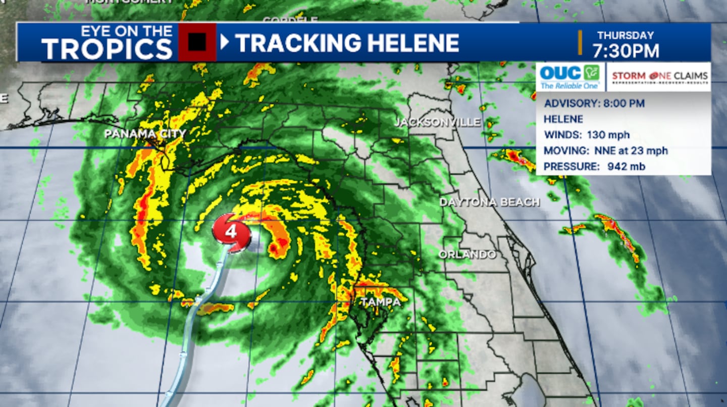
8 p.m. update:
Hurricane Helene is a major hurricane and is nearing landfall along the Big Bend.
The 8 p.m. advisory from the National Hurricane Center estimated maximum sustained winds to be 130 mph, making Helene a dangerous Category 4 major hurricane.
Additional strengthening is still possible before landfall later tonight.
A catastrophic storm surge of 15-20 feet is still forecast for Apalachee Bay and portions of the northern Big Bend, with the threat for widespread hurricane-force winds becoming highly likely in the area.
Tropical storm warnings continue for the vast majority of Central Florida, with a hurricane warning for western Marion County.
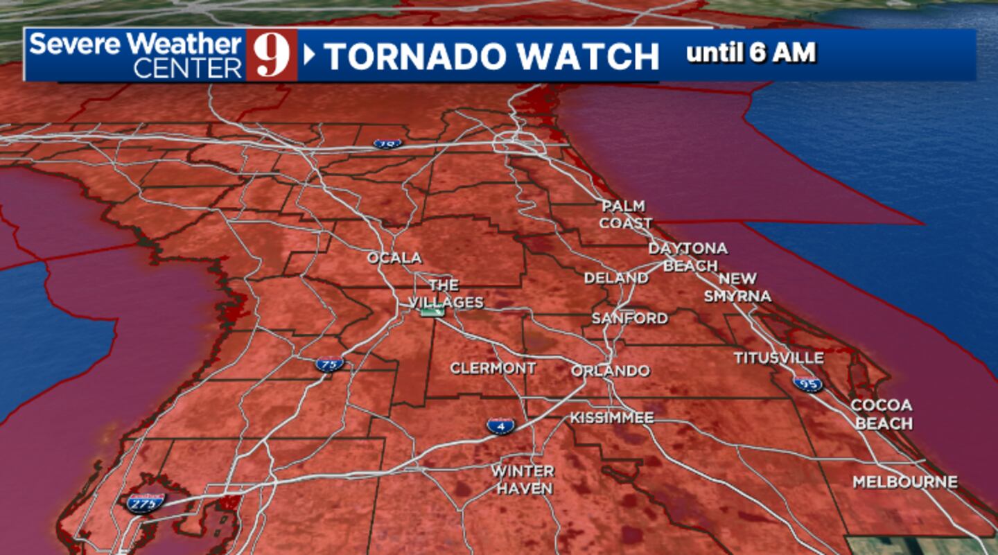
A new tornado watch has been issued for all of Central Florida until 6 a.m., as the threat of tornadoes will continue this evening and into the overnight.
7 p.m. update
The International Space Station captured video as it passed over Hurricane Helene.
See the video below:
6:53 p.m. update:
A tornado warning was issued for Polk County until 7 p.m.
These include Lakeland, Plant City and Medulla.
Tornado Warning including Lakeland FL, Plant City FL and Medulla FL until 7:00 PM EDT pic.twitter.com/L6ECnaMS95
— NWS Tornado (@NWStornado) September 26, 2024
6:19 p.m. update:
Hurricane Hunters have found Helene has become a dangerous Category 4 major hurricane.
Air Force Hurricane Hunters have found maximum sustained winds of 130 mph.
This makes Helene a Category 4 major hurricane in the Gulf of Mexico.
Helene will make landfall later tonight in the Big Bend, bringing catastrophic storm surge and extremely powerful hurricane-force winds.
Update 6:20 PM EDT Thurs: Helene now an extremely dangerous Category 4 hurricane
— National Hurricane Center (@NHC_Atlantic) September 26, 2024
A NOAA Hurricane Hunter aircraft currently investigating Helene recently found that the maximum sustained winds have increased to 130 mph (215 km/h). The minimum central pressure has also decreased… pic.twitter.com/8rqqf6fp38
6 p.m. update:
Florida Highway Patrol Sergeant Steve Gaskins spoke with WFTV about what drivers need to know as Hurricane Helene approaches.
See his tips in the video below:
5 p.m. update:
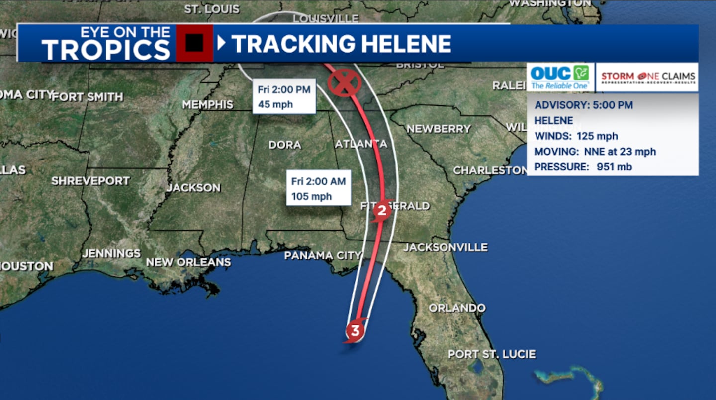
Meteorologist David Heckard said Helene continues to intensify in the Gulf of Mexico, with a major hurricane strike to the Big Bend increasingly likely.
The 5 p.m. advisory from the National Hurricane Center estimated maximum sustained winds to be 125 mph, making Helene a Category 3 major hurricane.
Additional strengthening is forecast, and Helene could be a Category 4 by landfall tonight.
A catastrophic storm surge of 15-20 feet is still forecast for Apalachee Bay and portions of northern Big Bend, with the threat of widespread hurricane-force winds becoming highly likely in the area.
Tropical storm warnings continue for the majority of Central Florida, with a hurricane warning for western Marion County.
A tornado watch continues for most of Central Florida until 8 p.m., and rain squalls with strong winds and isolated tornadoes are possible tonight.
4:27 p.m. update:
The National Weather Service has issued a Tornado Warning in Volusia County until 4:45 p.m.
Deltona, DeLand, and Orange City are included in this warning.
Tornado Warning including Deltona FL, DeLand FL and Orange City FL until 4:45 PM EDT pic.twitter.com/RqgfkuTOPE
— NWS Tornado (@NWStornado) September 26, 2024
4:10 p.m. update:
Gov. Ron DeSantis to speak in Tallahassee at 5:00 p.m. to give updates on Hurricane Helene.
Hurricane Helene is going to make landfall this evening in the Big Bend, but dangerous conditions will be present throughout the rest of the state—even outside the forecast cone. To stay safe from hazards like debris, downed power lines, and standing water, do not try to do any… pic.twitter.com/GM3R8TEPTg
— Ron DeSantis (@GovRonDeSantis) September 26, 2024
3:20 p.m. update:
Food delivery app DoorDash has suspended service in parts of Florida and Georgia over Hurricane Helene.
DoorDash said it has activated its “Severe Weather Protocol” and suspended operations across parts of Florida’s Big Bend and southern Georgia.
Read: New to Florida? 9 helpful tips to get you through a hurricane
The company said the decision was made to protect their delivery drivers from dangerous hurricane conditions, including storm surge, street flooding and strong winds.
The areas wee DoorDash operations has been temporarily suspended including Tallahassee, Panama City, Gainesville, Spring Hill, Fitzgerald, Americus, Douglas, Sylvester, Hawkinsville, and surrounding areas.
Officials said operations are expected to resume around 1 p.m. on Friday, but it depends on safety and ground conditions.
Watch: Utility companies across Central Florida brace for Helene
2:30 p.m. update:
The National Hurricane Center reported Hurricane Helene is now a Category 3 storm.
0 of 25


Helene now has maximum sustained winds around 120 mph.
Additional strengthening is possible before Helene makes landfall in the Big Bend on Thursday night.
2:25 PM Thursday Update: Air Force hurricane hunters (@53rdWRS) find #Helene a dangerous major hurricane. The maximum sustained winds have increased to 120 mph (195 km/h). Follow the latest at https://t.co/tW4KeGe9uJ pic.twitter.com/ODkUzeFpc1
— National Hurricane Center (@NHC_Atlantic) September 26, 2024
1:55 p.m. update:
The National Hurricane Center reported Hurricane Helene is right on the edge of becoming a Category 3 storm.
Helene now has maximum sustained winds around 110 mph. The storm will officially be upgraded to Category 3 with recorded winds of 111 mph.
As #Helene continues to approach the coast, please do not get overly focused on short-term wobbles in its track, "false" eye locations, or on specific computer model simulations.
— National Hurricane Center (@NHC_Atlantic) September 26, 2024
EVERYONE along the Florida Big Bend coast is at risk of potentially catastrophic storm surge and… pic.twitter.com/LEFNk9UhXv
The storm is moving north-northeast at 16 mph.
NHC says Helene will continue to rapidly intensify before making landfall in the Big Bend area of Florida.
Watch live continuing coverage on Channel 9.
1:30 p.m. update:
During severe weather, a power outage could leave you without access to much-needed electronics.
According to the Federal Emergency Management Agency, people should make sure everything is fully charged before a potential power outage.
Here are some tips to help ensure you stay connected if the power goes out:
Read: How to keep your electronics charged when the power is out
12:40 p.m. update:
Leaders in Orange County are planning to hold a news conference on Hurricane Helene on Thursday.
The news conference is planned for 3 p.m. from the Orange County Emergency Operations Center in Winter Park.
Orlando Utilities Commission, Duke Energy, and Orange County Public Schools representatives will also be on hand.
Read: Mayor of Orange County to give update on Hurricane Helene
11:50 a.m. update:
Universal Orlando Resort announced it has canceled its Halloween Horror Nights event on Thursday.
Update from Universal Orlando Resort.
— Universal Orlando Resort (@UniversalORL) September 25, 2024
For more information and FAQs, visit https://t.co/ZXiP45XgKc pic.twitter.com/qFiG9SgYTy
Other theme parks and attractions around Central Florida have announced closures or changes due to Hurricane Helene.
Read: Hurricane Helene: These Florida theme parks are closed for inclement weather
11 a.m. update:
The National Hurricane Center said Hurricane Helene has strengthened into a powerful Category 2 storm.
Helene has maximum sustained winds around 105 mph. It will become a Category 3 if it reaches winds of 111 mph.
Read: Hurricane safety: 16 tips that could save your life during a storm
The storm is moving north-northeast through the eastern Gulf of Mexico at 14 mph.
Forecast data continues to show Helene making landfall near Apalachee Bay in the Big Bend area of Florida.
Very large Hurricane #Helene strengthening and expected to make landfall as a major hurricane in the Florida Big Bend region this evening. A catastrophic and deadly storm surge is likely. Preparations should be rushed to completion. Here are the latest Key Messages.… pic.twitter.com/ht7XaEygSg
— National Hurricane Center (@NHC_Atlantic) September 26, 2024
Helene will bring catastrophic damage to the area.
The storm will speed up before making landfall which will help it maintain its strength as it moves over the southeastern U.S.
Read: Hurricane season: What is the Saffir-Simpson scale; how does it work; is there a Category 6?
Helene could remain a Category 1 hurricane as it moves over Atlanta or central Georgia Friday morning.
Channel 9 will continue to provide coverage of Hurricane Helene on WFTV.
10:40 a.m. update:
A tornado warning was extended to include parts of Volusia County.
The warning area includes parts of New Smyrna Beach, Edgewater and Glencoe.
Tornado Warning including New Smyrna Beach FL, Edgewater FL and Glencoe FL until 11:00 AM EDT pic.twitter.com/rp5MfJ5bKU
— NWS Tornado (@NWStornado) September 26, 2024
The advisory is expected to last until 11 a.m.
WFTV has live coverage on Channel 9.
10:18 a.m. update:
A Tornado Warning was issued for parts of Brevard County.
The advisory includes parts of Mims and Turnbull.
Tornado Warning including Mims FL and Turnbull FL until 10:45 AM EDT pic.twitter.com/igFcSJgD97
— NWS Melbourne (@NWSMelbourne) September 26, 2024
The warning is expected to last until 10:45 a.m.
WFTV has live coverage on Channel 9.
10:15 a.m. update:
Though Hurricane Helene is forecast to make landfall in the Big Bend area of Florida, the risk of flooding rain is still possible is parts of Central Florida.
Several areas in Central Florida have seen flooding during major storms over the last few months.
Outer rain bands from Helene could bring more flooding to parts of Central Florida as the storm continues its move through the eastern Gulf of Mexico.
Here are some things you can do before, during and after flooding occurs:
Read: What to do before, during and after a flood
9:25 a.m. update:
Airport officials around Florida said travelers need to check their flight status in advance due to Hurricane Helene.
Read: Check your flight: Most Central Florida airports open as Hurricane Helene strengthens
Most airports in Central Florida remain open and in normal operation.
Though Helene is projected to impact Florida’s Big Bend area, outer rain bands can still produce storms and tornados in our area.
Operational Update - Hurricane #Helene
— Orlando International Airport (@MCO) September 25, 2024
Our airport remains open and operational. We're currently making preparations ahead of Hurricane Helene & will continue to monitor the storm. Please check with your airline directly for updates regarding your flight.https://t.co/qaAAWSeMPO https://t.co/0pSi1JxyTW
Tampa International Airport suspended operations at 2 a.m. Thursday because of Helene.
The airport said it will remain closed to the public until after the storm passes.
8:35 a.m. update:
Gov. Ron DeSantis will hold a news conference Wednesday morning to give updates on Hurricane Helene.
Watch at 9 a.m.: Gov. DeSantis to give update on Hurricane Helene
The governor is planning to speak around 9 a.m. from the state emergency operation center in Tallahassee.
WFTV will have live coverage of DeSantis’ news conference on Ch. 9.
7:45 a.m. update:
The National Hurricane Center said Hurricane Helene has strengthened into a Category 2 storm.
Read: Hurricane safety: What are hurricane categories and what do they mean?
Helene now has maximum sustained winds around 100 mph.
The storm is moving north-northeast through the central Gulf of Mexico at 12 mph.
Hurricane #Helene Advisory 12A: Helene Becomes a Category 2 Hurricane With Significant Additional Strengthening Expected Before Landfall in Florida. Preparations to Protect Life and Property Should Be Rushed To Completion. https://t.co/tW4KeGe9uJ
— National Hurricane Center (@NHC_Atlantic) September 26, 2024
7 a.m. update:
A tornado watch advisory has been issued for nearly all of Central Florida.
The new advisory includes every Central Florida county except for Flagler County.
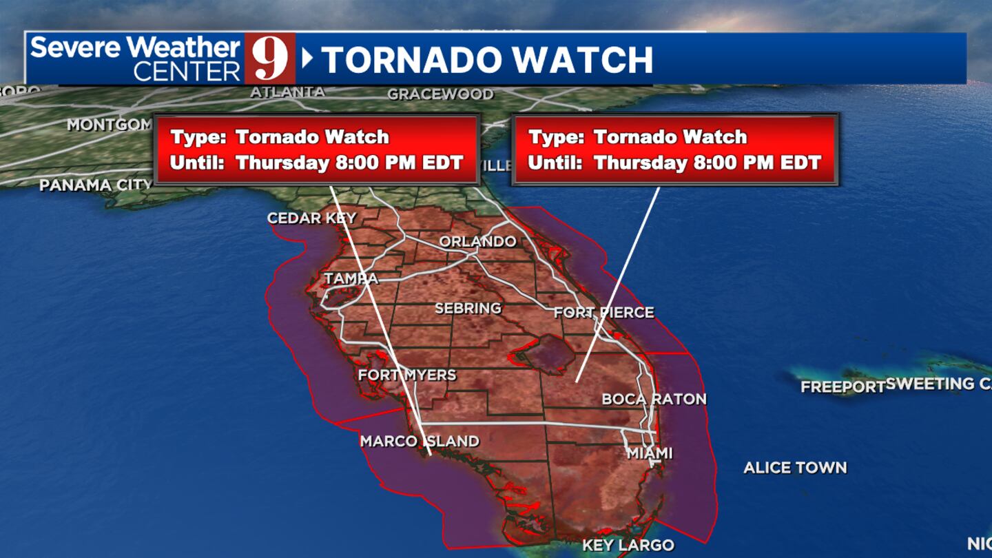
The tornado watch is expected to last until at least 8 p.m.
However, the tornado threat will last until midnight.
Read: Tornado Watch vs. Tornado Warning? What you need to know
A tornado “watch” is issued when tornadoes are possible, but it does not mean that they will occur. It only means they are possible.
Channel 9 Eyewitness News will have live coverage on WFTV if any tornado warnings are issued.
Original report:
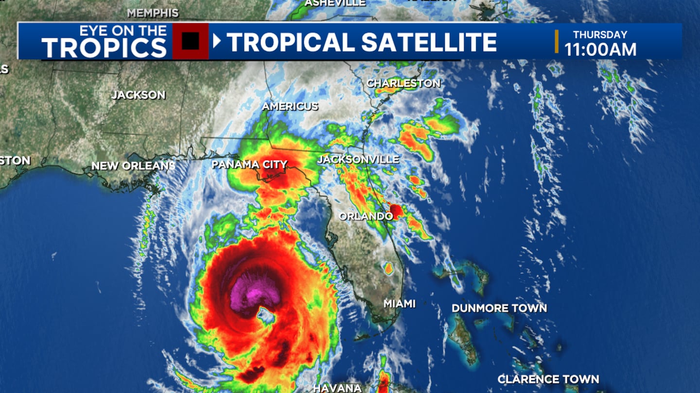
Hurricane Helene continues to strengthen as it moves through the Gulf of Mexico.
The storm is nearly a Category 2 storm and currently has maximum sustained winds around 90 mph.
Helene is expected to rapidly intensify in the next 20 hours.
Photos: Hurricane Helene to impact Florida as major storm
0 of 10


Helene is forecast to become a dangerous Category 3 hurricane before it impacts Florida Thursday night.
The storm is projected to make landfall in the Big Bend area of Florida from 6 p.m. to 9 p.m.
Good Thursday Morning,
— Brian Shields (@BrianWeather) September 26, 2024
I want to keep this in perspective best I can. It really feels each time there is a hurricane threat, that it is going to hit everyone. That is not the case, of course. (1/...) pic.twitter.com/Sa3YW6pS9N
Helene will bring dangerous winds and a catastrophic storm surge of 15 to 20 feet to Apalachee Bay and portions of northern Big Bend, with the threat of widespread hurricane-force winds increasing.
Read: Hurricane evacuation: Helpful apps for finding gas, hotel rooms, traffic routes
Tropical Storm Warnings continue for the vast majority of Central Florida, with a hurricane warning for western Marion County.
The biggest concern in Central Florida will be the risk of isolated tornados from Helene’s outer rain bands.
Read: Hurricane tips: What you should do to prepare
Conditions will worsen as the day progresses Thursday, as Helene quickly lifts northward.
Officials are urging residents in the path of the storm to evacuate.
0 of 26


Helene should be over Atlanta around 9 a.m. on Friday.
Channel 9 will continue to monitor Helene and provide updates on Eyewitness News.
Follow our Severe Weather team on X for live updates:

©2024 Cox Media Group


 Sign Up

