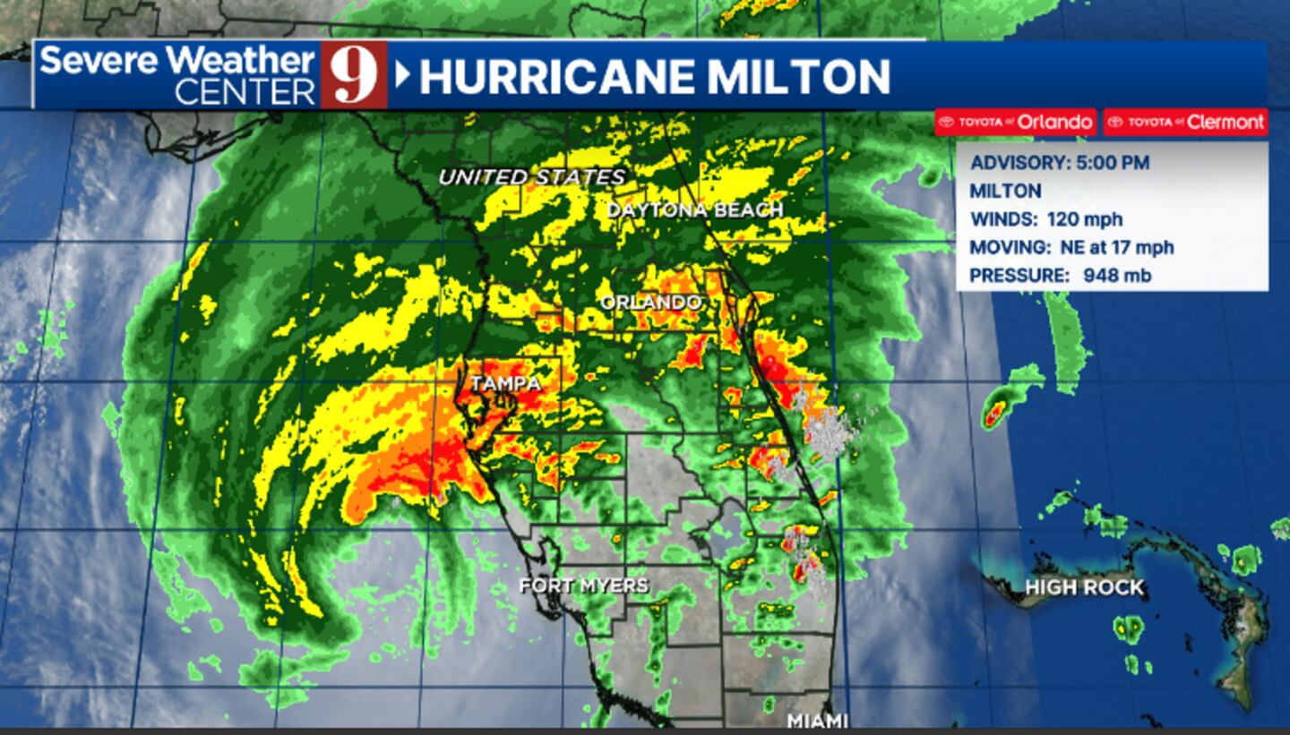
ORLANDO, Fla. — Meteorologists in Severe Weather Center 9 are tracking Hurricane Milton as it approaches Florida.
▶ WATCH CHANNEL 9 EYEWITNESS NEWS
▶ DOWNLOAD OUR APPS
See today’s updates here.
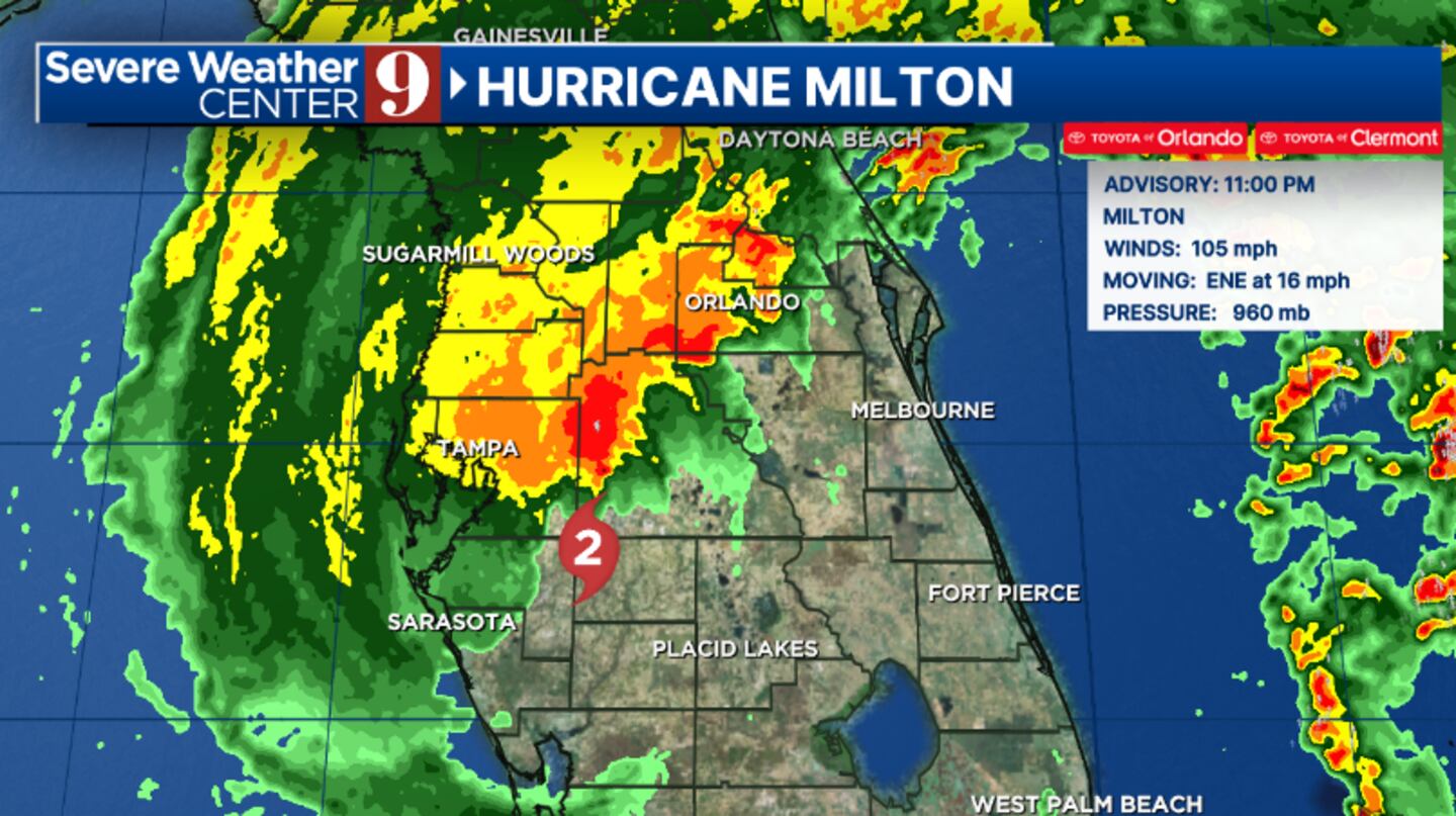
11 p.m. update
Meteorologist David Heckard said Hurricane Milton continues to slam much of Florida as a Category 2 storm.
Maximum winds are at 110 mph, with the center of circulation entering Polk County.
Winds continue to increase across Central Florida, with a 76 mph gust reported at Daytona Beach International Airport and a 63 mph gust at Kissimmee.
A significant Flash Flood Warning has been issued for much of Metro Orlando until 2 am.
Rainfall totals of 8 to 14 inches are becoming likely.
Hurricane-force winds continue to increase in parts of the area for the next few hours.
Flash Flood Warning including Orlando FL, Deltona FL and Pine Hills FL until 2:00 AM EDT pic.twitter.com/9iATti0FeY
— NWS Melbourne (@NWSMelbourne) October 10, 2024
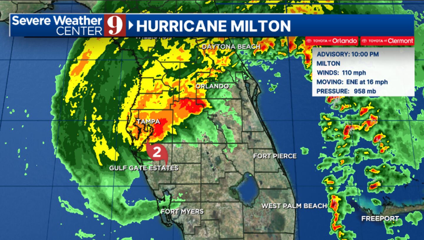
10 p.m. update
Milton is now over interior Manatee County and has decreased to Cat. 2 intensity.
Winds are now at 110 mph.
A rare flash flood emergency has now been issued for Polk and Southern Sumter Counties until 4 am.
This means “life-threatening flash flooding” is occurring in the area.
Winds continue to increase across Central Florida, and some areas will reach hurricane force in the coming hours.
Tampa continues to deal with major impacts, as hurricane-force winds continue to pound that area along with a 500-year flood event.
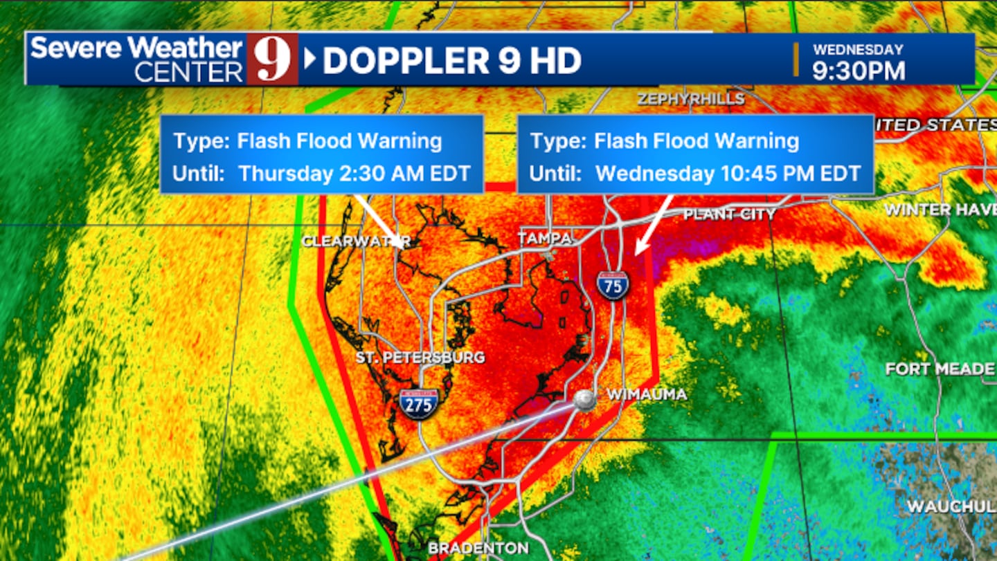
9:30 p.m. update
Meteorologist David Heckard said a rare flash flood emergency has been issued for the Tampa Bay Metro Area until 2:30 am.
Ten to 14 inches have fallen in this area, and more intense is likely.
The National Weather Service calls this “life-threatening flash flooding.”
9 p.m. update
Meteorologist David Heckard said Milton continues to slam much of Florida, as winds increase across Central Florida.
In the last hour, wind gusts of 61 miles per hour have been recorded at Daytona Beach International Airport, wind gusts of 60 mph reported at Orlando Executive Airport and wind gust of 63 mph were recorded at Sanford International Airport.
Winds will continue to increase throughout the evening and overnight, with hurricane-force winds likely in parts of the area.
Flooding rains will also continue, with the flash flooding threat increasing in areas north of the system’s core.
8:33 p.m. update
Meteorologist David Heckard said Hurricane Milton has made landfall near Siesta Key in Sarasota County.
Milton makes landfall as a Category 3 major hurricane, with winds of 120 mph.
The eyewall continues to severely impact the Tampa Bay metro area, where an Extreme Wind Warning remains in effect.
Winds will continue to increase across Central Florida this evening.
8 p.m. update:
Meteorologist David Heckard said Milton is nearing landfall as a Category 3 major hurricane along the Suncoast.
Landfall is imminent in Sarasota County in the next hour.
An Extreme Wind Warning continues for the Tampa Bay Metro Area and Manatee counties.
Winds will continue to increase in Central Florida, with some areas reporting wind gusts over 55 mph.
7:15 p.m. update:
Channel 9 reporter Melonie Holt shows the damage ahead of Hurricane Milton.
The damage is in Brevard County along the Florida A1A.
See the video below.
6:55 p.m. update:
A tornado warning has been extended for Brevard County until 7:15 p.m.
Tornado Warning including Brevard County, FL until 7:15 PM EDT pic.twitter.com/YZjgs32W2M
— NWS Melbourne (@NWSMelbourne) October 9, 2024
5:55 p.m. update:
A tornado warning was issued for some areas in Brevard County, including Merritt Island.
Tornado Warning including Merritt Island FL, Rockledge FL and Cocoa FL until 6:15 PM EDT pic.twitter.com/qsBqDMcQJl
— NWS Melbourne (@NWSMelbourne) October 9, 2024
5:30 p.m. update
A tornado warning was issued for some areas in Brevard County.
Tornado Warning including Merritt Island FL, Cocoa Beach FL and Satellite Beach FL until 5:45 PM EDT pic.twitter.com/JNvzr96yZW
— NWS Melbourne (@NWSMelbourne) October 9, 2024
5:15 p.m. update
As tornado warnings were issued across Central Florida, viewers captured photos of the weather.
This picture was sent into WFTV from viewer Jodi:
See how you can share your photos here.
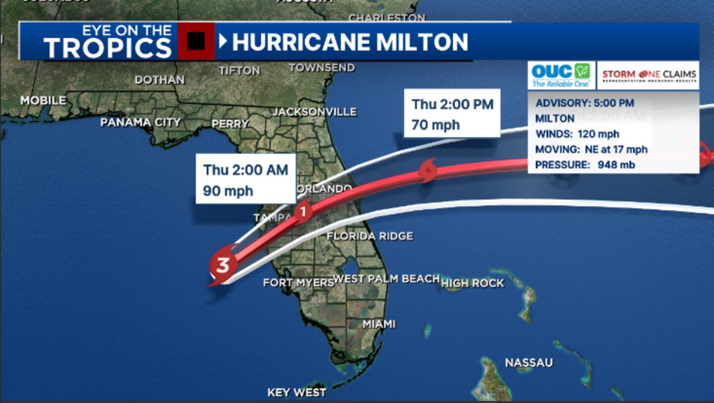
5 p.m. update
According to the National Weather Service, Milton is approaching West-Central Florida as a Category 3 storm.
There is a high chance of life-threatening storm surge, damaging winds and flooding rains expected across portions of Central and Southwest Florida.
Currently, Milton has maximum sustained winds of 120 mph, moving at 17 mph.
The central pressure is at 948 MB.
4:30 p.m. update
A tornado warning was issued for parts of Orange and Osceola Counties.
This advisory lasts until 5:15 p.m.
Tornado Warning including Conway FL, Azalea Park FL and Pine Castle FL until 5:15 PM EDT pic.twitter.com/6HulDu4cTv
— NWS Melbourne (@NWSMelbourne) October 9, 2024
3:30 p.m. update:
An active Tornado Warning has been extended into parts of southeastern Orange County.
The advisory also includes most of east Osceola County, including Holopaw and Dear Park.
Tornado Warning including Lake Mary Jane FL, Holopaw FL and Deer Park FL until 4:00 PM EDT pic.twitter.com/dY9sJT6Pmt
— NWS Melbourne (@NWSMelbourne) October 9, 2024
The Tornado Warning is expected to last until 4 p.m.
Watch live coverage of the alert on Channel 9.
3:18 p.m. update:
The National Weather Service said Florida has reported 53 tornado warnings Wednesday as of 3 p.m.
This comes as Hurricane Milton continues to make its way to impact Florida’s Gulf Coast.
10/9 at 3pm: Here is a view of all of the *Tornado Warnings* issued by NWS Tampa Bay, NWS Miami, and NWS Melbourne thus far.
— NWS Miami (@NWSMiami) October 9, 2024
As of 3pm, 53 total tornado warnings have been issued today...
41 issued by NWS Miami
Please remain aware for current and future tornado warnings! https://t.co/j3fr86cifC pic.twitter.com/Zc3WjqD7D6
The areas generating the tornado warnings have been moving north through Polk, Osceola and Brevard counties.
Channel 9 will have continuing coverage of active tornado warnings and Hurricane Milton on WFTV.
2:55 p.m. update:
The National Weather Service said a large portion of southeastern Central Florida is seeing multiple tornado warnings.
NWS released a map showing at least 8 active tornado warnings.
2:48 PM | All red-highlighted areas on this map are under a Tornado WARNING. As you can see, this is a large portion of east central Florida. Please have multiple ways to receive warnings and seek shelter if a warning is issued for your location! pic.twitter.com/gtTUnLwX0w
— NWS Melbourne (@NWSMelbourne) October 9, 2024
Some of the active areas are in Polk, Osceola and Brevard counties.
WFTV has live coverage of the storms now on Channel 9.
2:25 p.m. update:
A Tornado Warning has been issued for parts of Osceola County and Brevard County.
The advisory includes parts of southern Osceola County, including Yeehaw Junction, Kenansville, and Dear Park.
The advisory also includes the rural area of southwest Brevard County.
Tornado Warning including Brevard County, FL, Indian River County, FL, Osceola County, FL until 3:00 PM EDT pic.twitter.com/IXGu1iQoOU
— NWS Melbourne (@NWSMelbourne) October 9, 2024
The Tornado Warning is expected to last until 3 p.m.
Watch live coverage of the alert on Channel 9.
1:56 p.m. update:
A Tornado Warning has been issued in southern Brevard County.
Tornado Warning including Brevard County, FL, Indian River County, FL, Okeechobee County, FL until 2:30 PM EDT pic.twitter.com/8PMSRpHGH2
— NWS Melbourne (@NWSMelbourne) October 9, 2024
The advisory also includes Indian River County and Okeechobee County and is expected to last until 2:30 p.m.
Watch live updates now on Channel 9.
1:40 p.m. update:
Osceola County has announced a mandatory countywide curfew in effect from 8 p.m. on Oct. 9, until 10 a.m. on Oct. 10.
Volusia County has announced a mandatory curfew in effect from 8 p.m., Oct. 9 until 8 a.m. on Oct. 10.
Flagler County has announced a mandatory curfew for 7 p.m. Oct. 9 to 7: 30 a.m. Oct. 10.
1:34 p.m. update:
A tornado warning has been issued for Polk County.
1:13 p.m. update:
The National Weather Service shared photos on social media on Wednesday of a tornado crossing Interstate 75 as cars were still driving on the highway.
“TORNADO crossing I-75 as we speak! Seek shelter NOW!” the social media post said.
TORNADO just crossed I-75! https://t.co/RZCkn3LlSn pic.twitter.com/27R33J02Kk
— NWS Miami (@NWSMiami) October 9, 2024
12:25 p.m. update:
Florida Highway Patrol troopers have confirmed the Sunshine Skyway Bridge in the Tampa area has been shut down.
The massive bridge spans over 4 miles of Tampa Bay from St. Petersburg to Terra Ceia.
The bridge is closed by troopers for safety once sustained winds cross 45 mph.
#BREAKNG The Skyway Bridge is now CLOSED to all traffic. pic.twitter.com/nEm4NGAzB8
— FHP Tampa (@FHPTampa) October 9, 2024
It’s unlikely that the bridge will be reopened until after Hurricane Milton moves past the area.
Crews will also need to confirm the bridge is safe for drivers to access.
Read: Hurricane Milton: Travel impacted by storm, what you need to know
11:35 a.m. update:
The National Hurricane Center said Hurricane Milton has slightly weakened, but it is still a strong Category 4 storm.
Milton currently has maximum sustained winds around 145 mph and is moving northeast at 17 mph.
Here are the Key Messages for #Milton for early Wednesday - Preparations to protect life and property, including being ready for long-duration power outages, should be rushed to completion. The full advisory is at https://t.co/tW4KeGe9uJ pic.twitter.com/ET4T1SLB0V
— National Hurricane Center (@NHC_Atlantic) October 9, 2024
The storm’s track has slightly shifted to the south, but that will make little difference for our impacts in Central Florida.
Hurricane Milton is around 200 miles from Florida.
Milton should be nearing landfall around Sarasota late tonight.
Read: Hurricane Milton: Travel impacted by storm, what you need to know
11:10 a.m. update:
AdventHealth Centra Care is offering free urgent care video visits during Hurricane Milton.
The free health video visits will be offered from 8 a.m. Wednesday to 8 p.m. on Thursday.
People in Florida can access the video visits by downloading the AdventHealth App on your mobile phone and use the code MILTON to bypass payment pages.
“AdventHealth medical professionals will be available to provide virtual consultations and recommended treatment for urgent, non-life-threatening medical needs,” an AdventHealth spokesperson said.
For more information, visit AdventHealthVideoVisits.com.
10:20 a.m. update:
Gov. Ron DeSantis and other state leaders are giving an update on preparations for Hurricane Milton.
Watch DeSantis’ full news conference here:
9:30 a.m. update:
SunRail has temporarily suspended service due to Hurricane Milton.
The commuter train service that connects several counties in Central Florida will be closed Wednesday and Thursday.
After Milton passes, SunRail crews will need to access train tracks to ensure passenger safety before its service can resume.
LYNX officials said it will start pulling buses from its NeighborLink service starting at 3 p.m. Wednesday.
Safety officials will determine when LYNX can resume service after the storm passes.
All last trip schedules can be found here.
8:40 a.m. update:
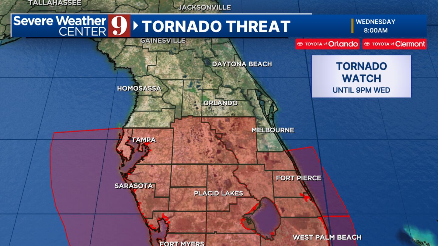
A Tornado Watch has been issued for Polk and Osceola counties.
The advisory also includes all of South Florida and is expected to last until 9 p.m. Wednesday.
The alert does not mean a tornado is happening now; it is only that the conditions are possible for them to form.
7:56 a.m. update:
The National Hurricane Center confirmed Hurricane Milton has slightly weakened and is now a Category 4 storm.
Milton currently has maximum sustained winds around 155 mph and is moving northeast at 16 mph.
The storm is forecast to remain a strong Category 4 hurricane before making landfall around midnight.
Wed 8am-The @NWSWPC is forecasting a high risk of flash flooding from #Milton with rainfall totals up to 18 inches over the Florida Peninsula. This rainfall brings the risk of catastrophic and life-threatening flash and urban flooding, along with moderate to major river flooding pic.twitter.com/GaHwJecfjS
— National Hurricane Center (@NHC_Atlantic) October 9, 2024
7:38 a.m. update:
Orlando Health says its hospitals are open and ready to treat the Central Florida community.
The hospital said it continues to monitor Hurricane Milton and prioritizes the safety of patients, their families, and its employees.
Orlando Health said some facilities will have altered hours due to Hurricane Milton. All emergency rooms will remain open until local authorities deem it unsafe to travel in the area.
Orlando Health physician and outpatient offices are closing at noon on Wednesday. Appointments for office visits scheduled after Oct. 9 at noon will be suspended and rescheduled.
Elective surgeries and procedures at hospital-based and ambulatory surgery center locations scheduled to start after noon on Wednesday, will be suspended and rescheduled.
Officials said normal operations are expected to resume Friday morning based on damage left behind from the storm.
Hurricane safety: 16 tips that could save your life during a storm
6:48 a.m. update:
Channel 9 meteorologist Biran Shields is breaking down the latest update from the National Hurricane Center.
“Hurricane Milton will be one of the most significant weather events we’ve had in Central Florida,” Shields said. “Hurricane impacts will be extensive.”
Shields believes that Milton could be stronger than previously forecasted as it moved over Central Florida.
Milton could be a Category 2 storm with wind gusts around 90 to 100 mph.
The storm will bring widespread tree damage and a major concern will be trees and large branches falling onto cars and homes.
The timing of the storm’s landfall should be around midnight near Anna Maria Island or Sarasota.
5:58 a.m. update:
Gov. Ron DeSantis is planning to hold a news conference Wednesday morning to share the latest details on Florida’s preparations for Hurricane Milton.
The governor will speak around 9:30 a.m. from the State Emergency Operations Center in Tallahassee.
Watch DeSantis’ full Tuesday afternoon update here:
Florida Division of Emergency Management Director Kevin Guthrie, Florida Department of Transportation Secretary Jared Perdue, Florida Department of Highway Safety and Motor Vehicles Director Dave Kerner, Florida Department of Law Enforcement Commissioner Mark Glass and Major General John D. Haas Adjutant General of Florida will join DeSantis at the event.
WFTV will have live coverage of DeSantis’ news conference on Channel 9 and wftv.com.
5:08 a.m. update:
The National Hurricane Center said Hurricane Milton remains a “catastrophic” Category 5 storm.
Milton currently has maximum sustained winds around 160 mph and is moving northeast at 14 mph.
Hurricane #Milton Advisory 17: Milton Remains a Catastrophic Category 5 Hurricane. Forecast to Make Landfall On the Florida Gulf Coast Late Tonight as a Dangerous Major Hurricane. https://t.co/tW4KeGe9uJ
— National Hurricane Center (@NHC_Atlantic) October 9, 2024
Current forecast models show Milton making landfall in Manatee County as a powerful Category 4 hurricane around 1 a.m. Thursday.
Tracks for the storm have shifted slightly to the north, according to NHC’s 5 a.m. update.
Milton could remain a Category 2 storm as it moves over Central Florida on Thursday morning.
2 a.m. update:
Meteorologist Brian Shields said the biggest thing to watch is the intensity on Wednesday.
Hurricane preps should be done. Be where you need to be for this hurricane by noon today.
Previous story:
Milton remains a powerful Category 5 hurricane as it moves toward Florida.
The 11 p.m. advisory from the National Hurricane Center indicates that Milton will be an intense Category 5 major hurricane with winds of 160 mph.
Milton is expected to weaken some as it approaches the state on Wednesday, but it is highly likely it will be a major hurricane at landfall.
The updated track shows Milton making landfall somewhere between the Tampa Bay area and the Suncoast early Thursday morning. It is then expected to track across Central Florida overnight Wednesday into Thursday.
Read: Which Central Florida counties have issued mandatory evacuations?
A portion of the West Coast is likely to experience a major hurricane strike. Catastrophic storm surges, hurricane-force winds, and flooding rains are all likely.
Milton will have significant impacts on Central Florida. Hurricane-force winds over 74 mph, flooding rainfall of 8-14 inches, and a few tornadoes are becoming likely.
Stay with Channel 9 for updates on Milton.
Follow our Severe Weather team on X for live updates:
©2024 Cox Media Group


