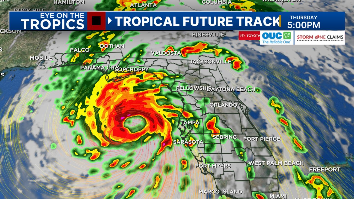
ORLANDO, Fla. — Tropical Storm Helene formed in the western Caribbean on Tuesday and is expected to become a major hurricane in the Gulf of Mexico.
▶ WATCH CHANNEL 9 EYEWITNESS NEWS
11:00 p.m. update:
#Helene continues to organize and should become a hurricane by Wednesday morning or afternoon.
The storm is still tracking toward Florida’s “Big Bend” by Thursday evening. This will have a big wind field, mainly on the eastern side bringing all of Central Florida under the tropical storm threat on Thursday.
Locally 3-6 inches of rain is possible, depending on how close the heavy bands get. Tornado threat also increases on Thursday.
“Life threatening” storm surge is expected along the Florida west coast, especially near and east of the landfall of #Helene on Thursday evening.
We’ll also have sizable storm surge along the west coast near Tampa.
We don’t have any surge advisories for our east coast, but could see some three feet rise in water levels on Thursday as the onshore winds increase, and we’ll be watching for any wave run-up along with any heavy rain bands.
9:00 p.m. update:
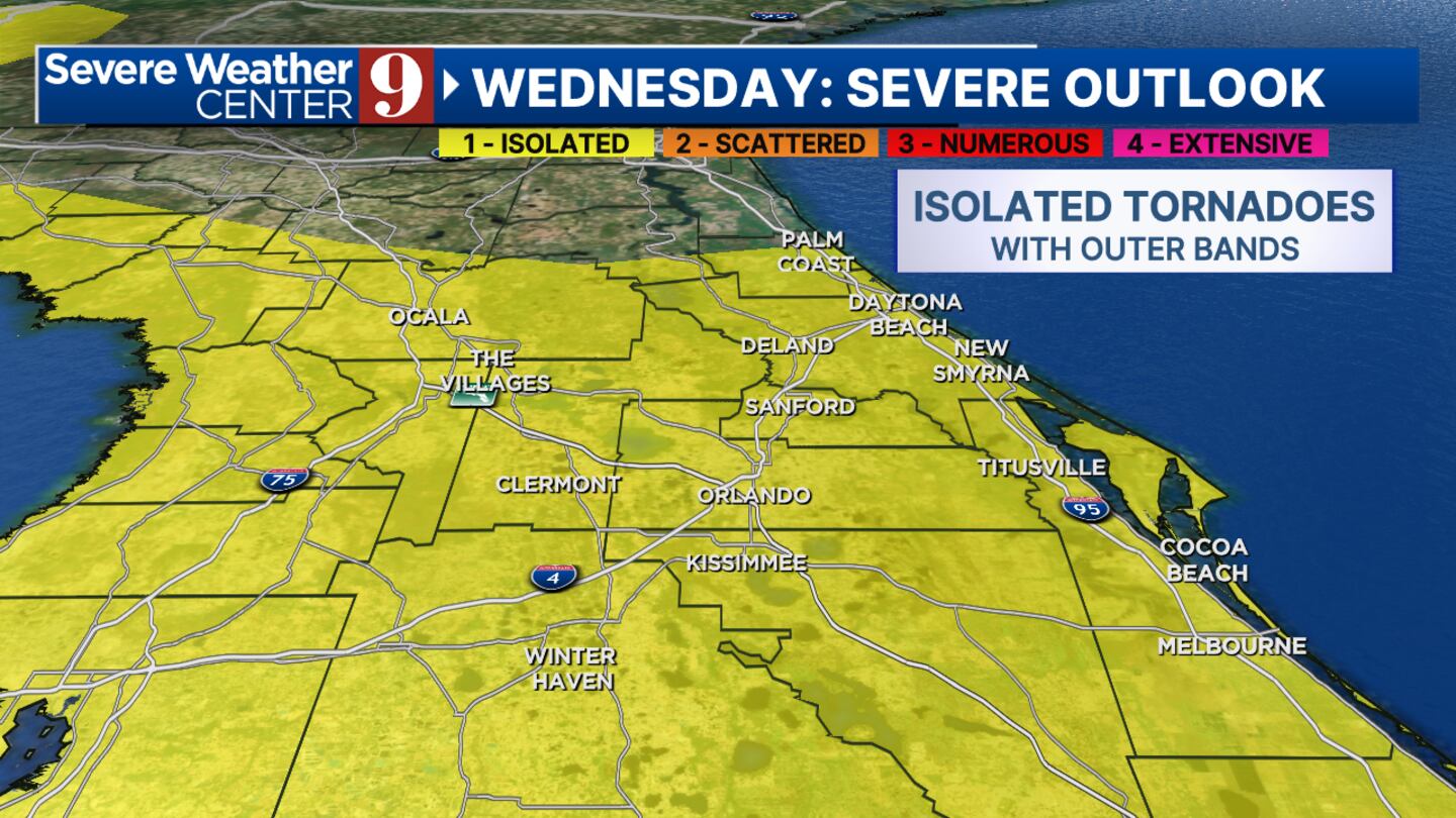
Central Florida be on the right-hand side of #Helene which puts us at higher risk for fast-moving tornadoes within the outer rain squalls from the storm. The threat will increase during the day on Thursday as the storm’s wind field strengthens and should diminish as the storm moves away early Friday.
5:15 p.m. update:
Helene could reach winds of up to 50 miles per hour and reach major hurricane status off Florida’s west coast on Thursday.
Helene could make landfall late on Thursday with huge wind, rain, and power outage issues for North Florida and along the “Big Bend.”
Some parts of Central Florida could have power outage issues depending on the squalls which will be more numerous and intense locally on Thursday.
A slight chance for flooding is also possible in our area with 3-6 inches of rain possible, and up to 8 inches with repeat squalls.
12:45 p.m. update:
The Sumter County School Board announced Sumter Schools will be closed on Thursday and Friday.
11 a.m. update:
Helene is forecast to strengthen into a Hurricane by Wednesday morning as it nears the Yucatan Peninsula.
It will then lift north into the Gulf of Mexico over very warm water, where it will continue strengthening.
Helene will most likely become a Cat 3 by Thursday morning as it quickly approaches the Florida coastline.
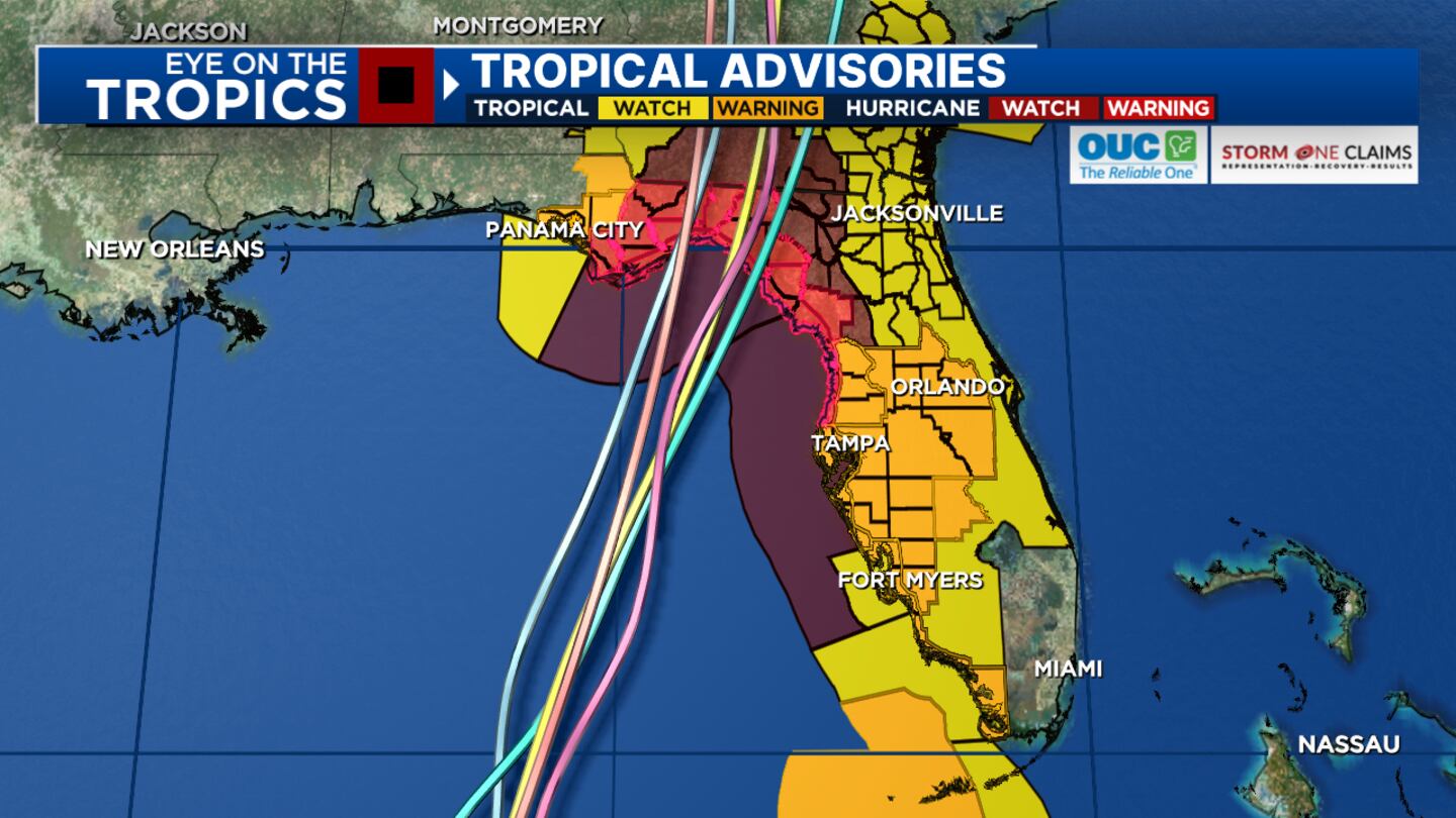
Some of the worst impacts will be felt along the coast from Panama City, Florida, to Cedar Key, Florida, with a landfall expected by Thursday evening.
Locally, Channel 9 will be tracking gusty showers with the outer rain bands from Wednesday to Friday.
Gusty winds, heavy rain, and isolated tornadoes will be our largest concerns here in Central Florida.
The storm is forecast to move north into the Gulf of Mexico over the next 24 hours.
Tropical Storm #Helene Advisory 5: Tropical Storm Helene Forms Over the Northwestern Caribbean Sea. Hurricane and Storm Surge Watches Remain in Effect For Portions Of the Florida Gulf Coast. https://t.co/tW4KeGe9uJ
— National Hurricane Center (@NHC_Atlantic) September 24, 2024
Helene is projected to become a major hurricane before making landfall Thursday night in the Big Bend area of Florida.
Helene is moving northwest at 8 mph and has maximum sustained winds of around 35 mph.
10:40 a.m. update:
Gov. Ron DeSantis held a news conference Tuesday morning to share more details on Florida’s preparations for the tropical system.
Watch DeSantis’ full news conference here:
9:30AM Update from Governor Ron DeSantis on Potential Tropical Cyclone 9 from Tallahassee pic.twitter.com/snczBE915e
— Ron DeSantis (@GovRonDeSantis) September 24, 2024
During the news conference, DeSantis announced that he has expanded the number of Florida counties placed under a “state of emergency” order.
Watch: Action 9: How to prepare before the storm
The number of Florida counties under a state of emergency has expanded from 41 to 61.
8:30 a.m. update:
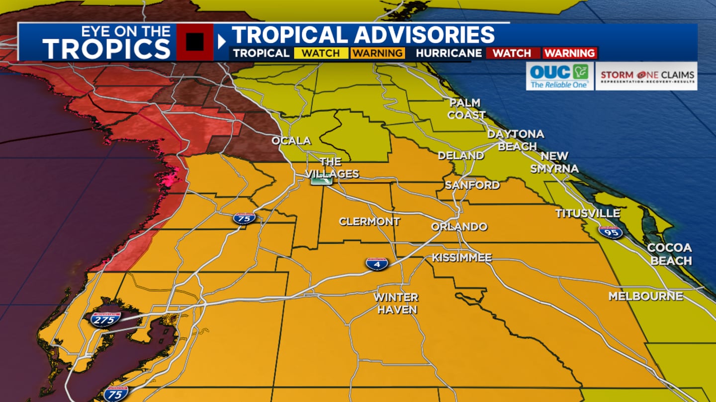
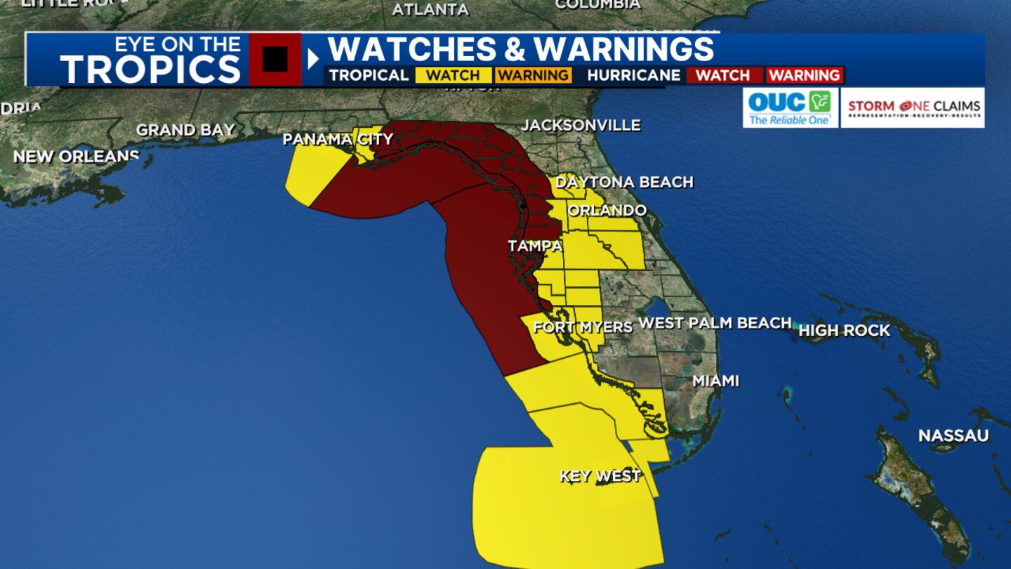
A Tropical Storm Watch advisory has been expanded to include Marion County.
The advisory already included Sumter, Polk, Lake, Orange, Osceola and Seminole counties.
The Nation Hurricane Center said hurricane and storm surge watches in effect for parts of Florida’s Gulf Coast.
NOAA’s Hurricane Hunter aircraft is flying into the disturbance to record detailed measurements of its ongoing development.
Original report:
Soon-to-be Helene is forecast to become a tropical storm on Tuesday and a hurricane on Wednesday.
Data shows the storm is on track to make landfall Thursday evening as a powerful hurricane in the Big Bend area of Florida.
Watch: See where you can get sandbags in Central Florida
The storm is looking to follow the same path that Hurricane Debby took last month.
Central Florida could see strong rain bands on Thursday and Thursday night.
The rain bands will bring an isolated tornado risk and gusty winds.
Read: Florida activates price gouging hotline
Most of the heaviest rain and wind will be in our western counties.
As of Tuesday morning, Sumter, Polk, Lake, Orange, Osceola and Seminole counties are all under a Tropical Storm Advisory.
Read: Hurricane watch vs. warning? Remembering the difference is a piece of pie
People in Central Florida should make general preparations for the storm, similar to what was done for Debby.
Residents should secure outdoor items and check their hurricane kits.
There is still time for the storm to shift further to the east, which would have a considerable impact on Central Florida.
Follow our Severe Weather team on X for live updates:
©2024 Cox Media Group

